High-Resolution Species Mapping in the Italian Alps
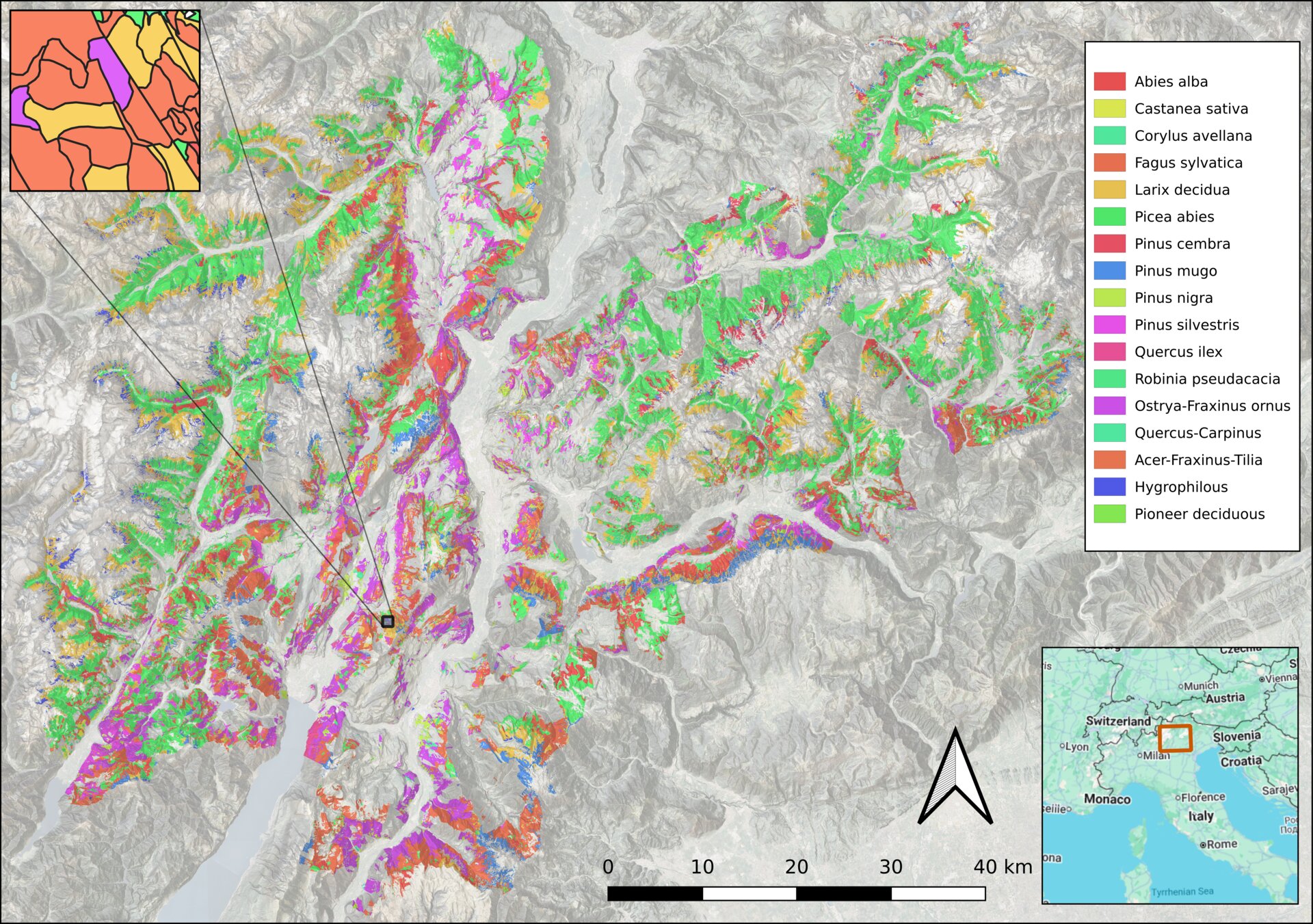
Our flagship project evaluates two geospatial foundation models (Tessera and AlphaEarth) for tree species classification across 6,200 km² of the Autonomous Province of Trento. Using parcel-level forest inventories as reference data, we demonstrate that FM embeddings substantially outperform conventional satellite approaches, achieving higher accuracy with far fewer training labels while preserving ecologically meaningful structure aligned with functional and taxonomic groupings.
Jan – Jul 2026
Continental Vegetation Mapping of Latin America
Integrating Tessera foundation model embeddings with the SynTreeSys network — approximately 10,000 high-quality tropical forest plots spanning all major Neotropical biomes — to produce the first harmonised, AI-driven vegetation and habitat map of Latin America. The project will cover Amazon, Cerrado, Atlantic Forest, Chaco, Andes, and Mesoamerican biomes at 10–30 m resolution, aligned with IUCN habitat classification and WWF ecoregions.
Planned
Amazon Functional Ecology at Continental Scale
Three interconnected ecological questions powered by foundation model embeddings: (1) Can embeddings recover continental-scale functional composition, mapping community-weighted wood density, SLA, and seed mass continuously at 10–30 m? (2) Are ecosystems discrete states or continuous manifolds in embedding space — revisiting the century-old Clements vs. Gleason debate with modern AI? (3) Do forests shift predictably along functional axes under disturbance, offering early warning signals for tipping points?
In Progress
Mapping Landscape Recovery in Cumbria
Establishing baseline habitat maps across approximately 86,500 hectares encompassing Cumbria’s five Landscape Recovery schemes, the Cumbria Connect initiative, and National Trust estates. Using Tessera to classify natural, semi-natural, and farmed habitats from 2017 to 2025, providing essential reference points for tracking 20–30 year restoration outcomes. Cumbria accounts for roughly 20% of the total Landscape Recovery area nationally.
In Progress
Evaluating Rewilding in the Cairngorms
Supporting the Cairngorm Connect initiative — an ambitious 200-year vision for rewilding across the Cairngorms — by integrating Tessera embeddings with Scotland’s National LIDAR Programme. The combination of continuous spectral-temporal monitoring with structural 3D data enables automated assessment of ecosystem recovery trajectories, distinguishing between spectrally similar but structurally distinct habitats.
Change Detection with Field Datasets
Leveraging outstanding field datasets from Spain and New Zealand to evaluate Tessera’s ability to detect gradual ecological changes (ecosystem recovery) and abrupt disturbances (fire, storm damage). A fundamental test of foundation model sensitivity to temporal ecological dynamics.
Embeddings vs Ecoregions
Quantifying how effectively different landcover types separate within Tessera’s latent embedding space using Jung’s 47 IUCN habitat types. Testing whether biome clustering, habitat integrity, and compositional coherence are encoded in the learned representations, using Generalised Dissimilarity Modelling.
Global Habitat Map
The ultimate goal: a globally consistent habitat map by end of 2026. Powered by the Global Plot Alliance — assembling a comprehensive database of vegetation plots worldwide, including access to 3.3 million plots through SPlot — and combining foundation-model embeddings with Michael’s implicit labelling approach for scalable habitat classification.
UK National Habitat Condition Mapping
Developing the next generation of habitat condition mapping systems for the UK, integrating Tessera with EUNIS classification standards. Moving beyond broad land cover categories to fine-scale habitat condition monitoring — distinguishing, for example, between overgrazed and undergrazed grasslands. Partnership with UK-CEH and DEFRA.
The Global Plot Alliance
To take full advantage of foundation models, we need expertly curated ground-truth datasets. We are building a global alliance of vegetation plot networks — assembling millions of survey records from botanists, ecologists, and foresters worldwide — to provide the reference data that will power the next generation of AI-driven habitat maps.
Partners include SPlot (3.3M plots), SynTreeSys, BIEN, UNEP-WCMC, and others.