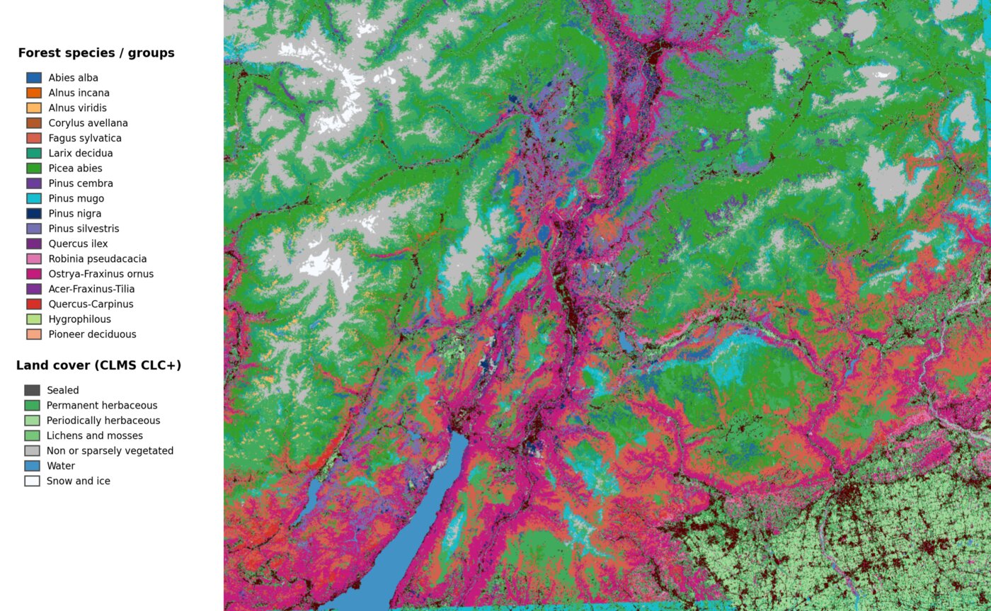
Home Trentino

High-Resolution Species Mapping in the Italian Alps

Geospatial foundation models enable data-efficient tree species mapping in temperate montane forests, substantially outperforming conventional satellite-based approaches.

18 species classes 10 m resolution 6,200 km² Autonomous Province of Trento

Study Area

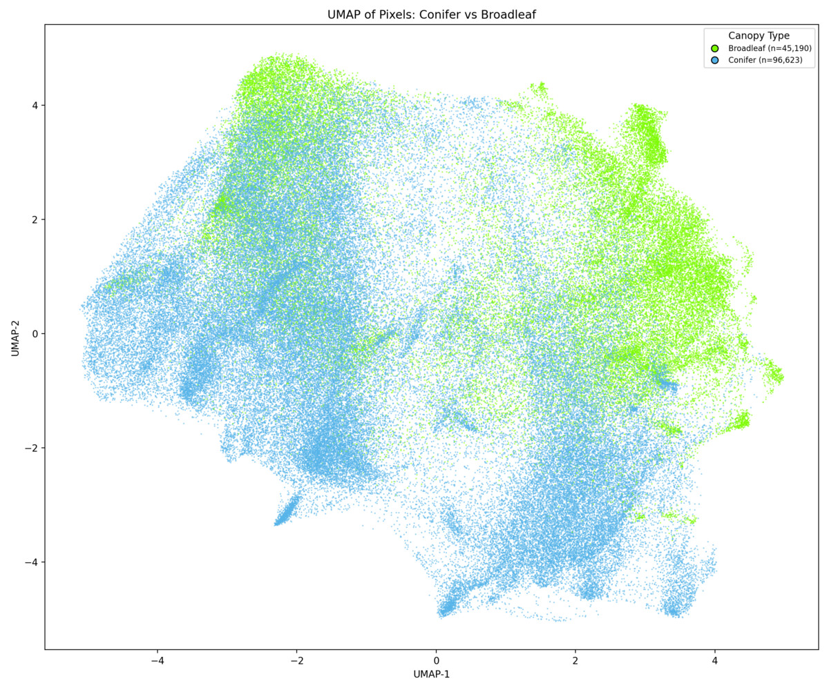
The Autonomous Province of Trento in northern Italy provides a demanding test case for species-level mapping: steep environmental gradients spanning 65–3,769 m elevation, mixed-species stands, and strong phenological variability throughout the year. The dense parcel-level forest inventory provides species composition data for over 83,000 forest parcels.

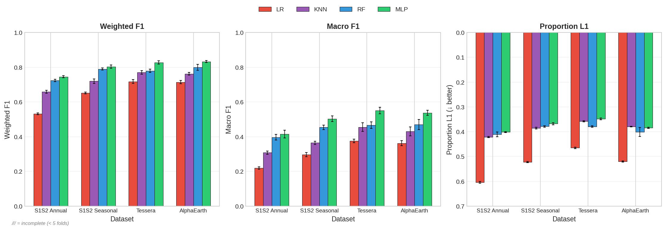
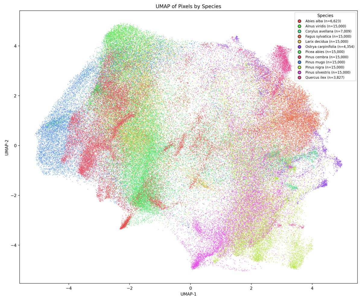
We classify 18 species and species groups, including both conifers (Picea abies, Larix decidua, Pinus sylvestris) and broadleaf species (Fagus sylvatica, Quercus ilex, OstryaFraxinus ornus), capturing the full range of Alpine forest diversity.

Bidirectional reflectance distribution function (BRDF) effects from variable illumination, steep slopes, and shadowing make conventional spectral approaches unreliable in mountainous terrain — exactly the conditions where foundation model embeddings can demonstrate their advantage.
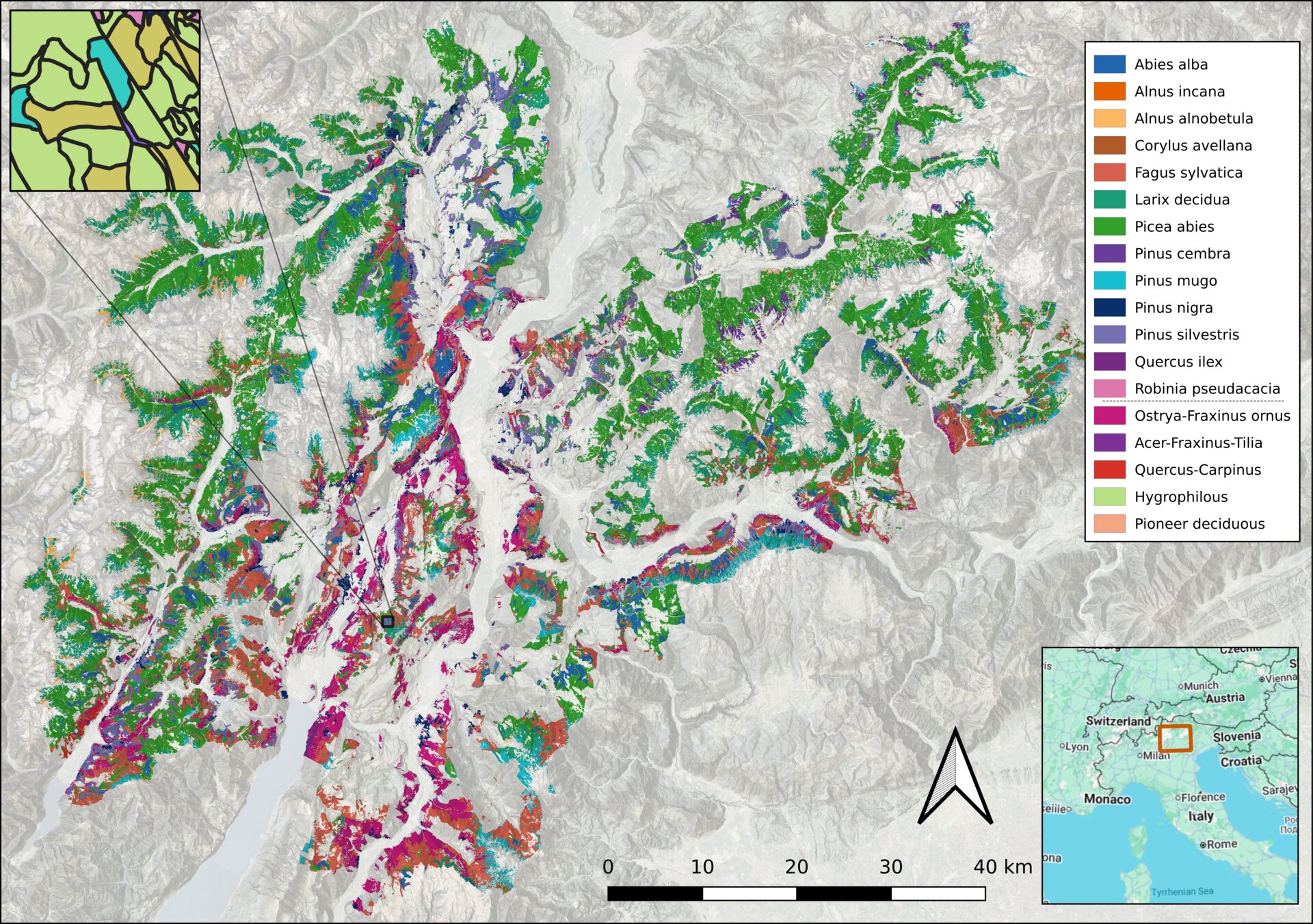
Map of tree species across the Trentino region

Wall-to-wall species predictions across the Trentino landscape.

Methods

We compare two globally pre-trained foundation-model embeddings against conventional Sentinel-1/2 composites, evaluating performance along five experimental axes.

Tessera

128-dimensional embeddings from multi-sensor seasonal composites (Sentinel-1 + Sentinel-2), capturing spectral-temporal dynamics at 10 m with annual global coverage.

AlphaEarth (AEF)

64-dimensional embeddings from Google's AlphaEarth Foundations system, encoding multi-source satellite data (Sentinel-1, Sentinel-2, Landsat) with auxiliary targets including LiDAR structure and climate variables.

Sentinel Composites (Baseline)

Conventional seasonal median composites from Sentinel-1 SAR and Sentinel-2 multispectral imagery — the standard approach in ecological remote sensing.

Soft-Label Training

Pixel-level targets are defined by parcel-level species proportions, enabling mixed parcels to contribute training signal via probabilistic soft targets rather than hard dominant-species assignments.

Five Experimental Axes

1

Classification accuracy & ecological structure

2

Label efficiency as data is reduced

3

Robustness to label impurity

4

Contribution of ancillary covariates

5

Cross-year temporal transfer

Key Results

Result 1

Foundation Models Substantially Outperform Satellite Composites

Both Tessera and AlphaEarth embeddings achieve significantly higher classification accuracy than conventional Sentinel-1/2 composites across all metrics. Performance gains are largely driven by embedding quality rather than downstream model capacity.

A compact neural network (MLP) provides the best results, outperforming Random Forest while matching deeper architectures — suggesting the embeddings already encode rich, species-discriminative structure.

Bar chart comparing classification accuracy across representations and classifiers

Classification performance across representations and classifier types. Foundation model embeddings (Tessera, AlphaEarth) vs conventional Sentinel composites.

Result 2

Embedding Structure Reflects Ecological Organisation

UMAP projections of foundation model embeddings reveal that the latent space naturally separates species along ecologically meaningful axes. Conifers and broadleaves form distinct macro-clusters, while individual species and genera occupy well-defined regions — all without any ecological supervision during pre-training.

UMAP colored by species (Tessera)

Species — Tessera 2018

UMAP colored by genus (Tessera)

Genus — Tessera 2018

UMAP colored by conifer/broadleaf (Tessera)

Conifer vs Broadleaf — Tessera 2018

UMAP colored by species (AlphaEarth)

Species — AlphaEarth 2018

UMAP colored by conifer/broadleaf (AlphaEarth)

Conifer vs Broadleaf — AlphaEarth 2018

UMAP colored by elevation (Tessera)

Elevation gradient — Tessera 2018

Label efficiency curves showing performance vs training data fraction

Classification performance as training data is progressively reduced.

Result 3

Foundation Models Are Radically More Label-Efficient

When training data is progressively reduced, foundation model embeddings degrade far more gracefully than conventional composites. Tessera and AlphaEarth maintain strong performance with a fraction of the labels that baselines require.

This is critical for practical applications where labelled ecological data is expensive, sparse, and regionally uneven — opening the door to species mapping in data-poor regions.

Result 4

Robust to Label Impurity

Classification accuracy remains stable even when moderately impure (mixed-species) parcels are included in the training data. This allows the full forest inventory to be utilised without aggressive filtering, maximising data volume.

Furthermore, incorporating parcel-level species fractions as soft labels during training helps the model extract information from mixed stands, improving performance for rarer species that typically occur in mixed parcels.

Classification performance across different label purity thresholds

Performance across label purity thresholds for different representations.

Cross-year temporal transfer performance

Classification performance when models trained in one year are applied to subsequent years.

Result 5

Temporal Transfer: The Key Challenge

Cross-year transfer reveals notable performance degradation, particularly for rare species. Interannual variability in phenology and satellite acquisition conditions affects model transferability across years.

This highlights the importance of multi-year training strategies and temporal alignment in operational forest monitoring — a key direction for future work.

Output

Wall-to-Wall Species Map

The final species-prediction map across the entire Trentino landscape at 10 m resolution, produced using Tessera embeddings and an MLP classifier trained with soft labels.

Wall-to-wall tree species map of the Trentino region

Key Takeaways

Embeddings encode species-discriminative information

Foundation model representations capture rich ecological structure aligned with functional and taxonomic groupings, without any ecological supervision.

The bottleneck shifts from features to labels

Foundation models reduce the need for hand-crafted features. The primary challenge becomes the availability, quality, and temporal alignment of reference data.

Simple classifiers suffice

A compact MLP matches or exceeds deeper models when applied to FM embeddings, suggesting the heavy lifting is done by the pre-trained representations.

Scalable to new regions

The data-efficient pipeline can be adapted to new study areas with limited local labels — opening the door to global species-level habitat mapping.

Read the Full Paper

Geospatial foundation models enable data-efficient tree species mapping in temperate montane forests.
Ball, Wicklein, Feng, Knezevic, Atzberger, Dalponte & Coomes.